

Walks around Polzeath
Enjoy the walks by being guided by the app


-
3.7 miles/6 km - Easy
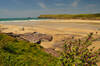
Polzeath to St Enodoc Church

Polzeath to St Enodoc Church
3.7 miles/6 km - Easy
A circular walk along the coast from Polzeath past a number of small coves to the vast sandy beach at Daymer Bay, returning through the dunes past St Enodoc Church which was once so deeply buried in the sand that entrance for services was through the roof.
-
5.8 miles/9.4 km - Easy-moderate
Rock to Polzeath

Rock to Polzeath
5.8 miles/9.4 km - Easy-moderate
A circular walk across the dunes and headland between Rock and Polzeath, returning via St Enodoc Church, where Sir John Betjeman is buried.
-
2.9 miles/4.7 km - Moderate
Port Quin to Lundy Bay

Port Quin to Lundy Bay
2.9 miles/4.7 km - Moderate
A circular walk from the fishing village of Port Quin to the golden sandy beaches of Epphaven Cove and Lundy Bay with spectacular coastal scenery, via the cliff-edge folly on Doyden Point built as a gambling den.
-
4.2 miles/6.7 km - Moderate
The Rumps to Polzeath around Pentire Point

The Rumps to Polzeath around Pentire Point
4.2 miles/6.7 km - Moderate
A circular walk across the Iron Age hillfort on the twin headlands of The Rumps and around Pentire Point, with panoramic views of the Camel Estuary and the offshore islands, to the sandy beach at Polzeath.
-
9.4 miles/15.1 km - Moderate-strenuous
Port Isaac to Polzeath (via bus)

Port Isaac to Polzeath (via bus)
9.4 miles/15.1 km - Moderate-strenuous
A one-way coastal walk, made circular via an initial bus journey, from Port Isaac to Polzeath along the Rollercoaster Path to Port Quin, the golden beaches of Lundy Bay via the Iron Age hillfort on the twin headland of The Rumps.


Download the iWalk Cornwall app and use the QR scanner within the app to find out more about any of the walks above.
For a walk finishing at Polzeath, the Polzeath to St Enodoc church walk is ideal. The Pentire Point walk also reaches Polzeath about half a mile from the end, so it's not too long a walk back after some time on the beach. There are also some walks further up the Camel Estuary at Rock and on the other side at Padstow.
